yahoo Press
Tropical Storm Isaias tracker: First Atlantic hurricane of the season expected to hit U.S. Gulf Coast
Images
1 / 6

2 / 6

3 / 6
4 / 6

5 / 6

6 / 6
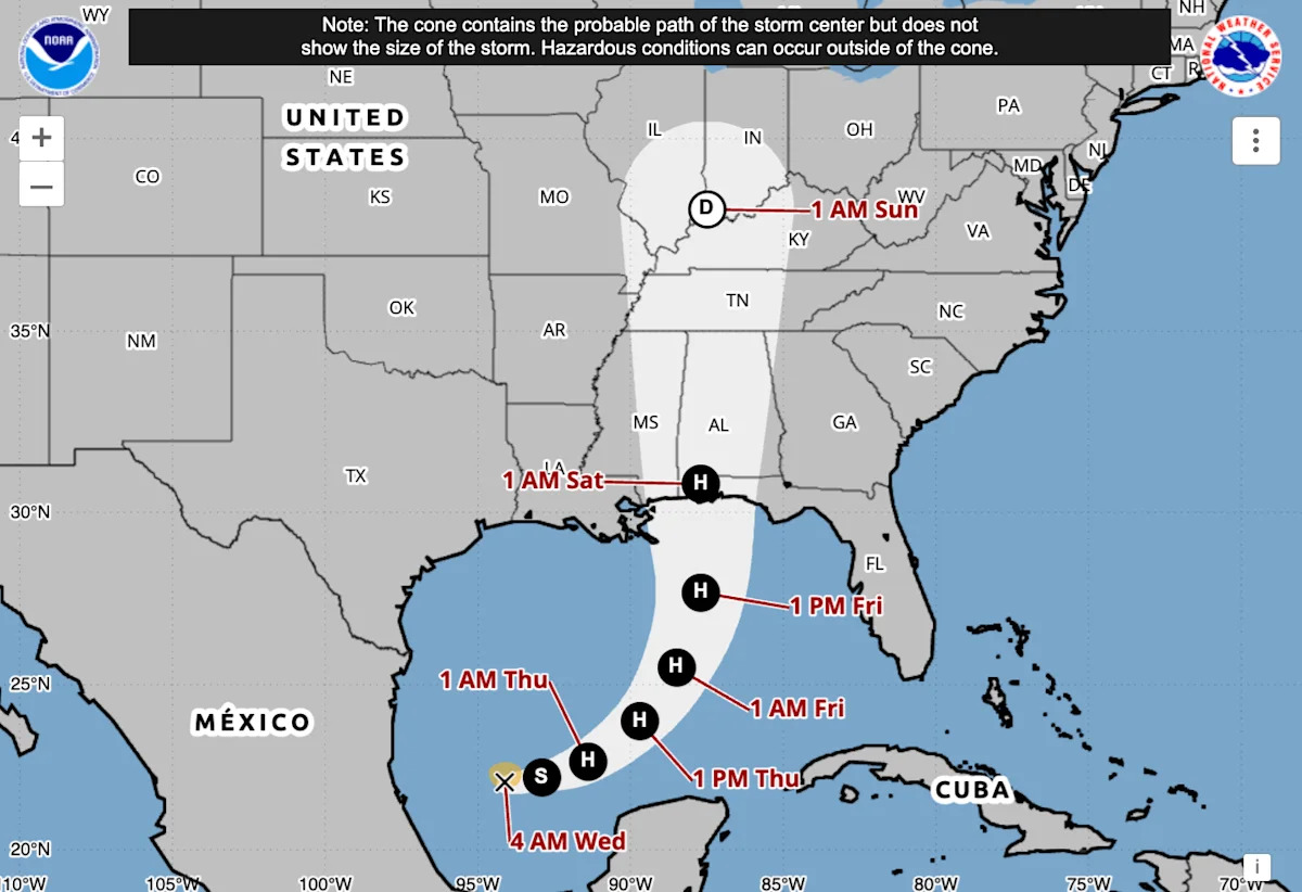
Tropical Storm Isaias formed in the Gulf on Wednesday and is expected to become the first Atlantic hurricane of the season, forecasters say.

According to the National Hurricane Center in Miami, the storm will strengthen as it moves toward the U.S. Gulf Coast later this week, becoming a hurricane by Thursday. It could peak as a Category 2 storm with maximum sustained winds of 110 mph by Thursday night before weakening as it approaches the coast.

It's unclear exactly where Isaias might make landfall. Current models show the center of Isaias coming onshore anywhere from eastern Louisiana to the western Florida Panhandle. Florida Gov. Ron DeSantis declared a state of emergency for 25 counties ahead of the storm.

Is the storm headed your way? Follow it in real time on the new Yahoo Weather app.

The NHC said there was "an increasing risk of dangerous wind and storm surge impacts along portions of the northern Gulf Coast," adding that floods will be possible due to heavy rainfall. Isaias is expected to produce rainfall amounts of 3 to 6 inches from far southeastern Louisiana to the Florida Panhandle. Some areas could see up to 10 inches of rain.

The Atlantic hurricane season, which runs from June to November, has not gone this late in the year without a hurricane since 1905, according to the Associated Press. A typical Atlantic hurricane season produces 14 named storms, of which seven become hurricanes. This year, there have been nine named storms, and no hurricanes.

According to the hurricane center's latest advisory, as of 11 a.m. ET on Wednesday:

Isaias was located about 540 miles southwest of the mouth of the Mississippi

It had maximum sustained winds of 45 mph

It was moving east-northeast at 8 mph

Hurricane, tropical storm and storm surge watches have been issued across portions of the northern Gulf Coast.

A hurricane watch is in effect for:

Bay St. Louis, Miss., to Indian Pass, Fla.

A tropical storm watch is in effect for:

The Jefferson/Plaquemines Parish line in Louisiana to Bay St. Louis, Miss.

Indian Pass, Fla. to Aucilla River, Fla.

A storm surge watch is in effect for:

The mouth of the Mississippi River to Yankeetown, Fla.

A hurricane watch means that hurricane conditions are possible within the watch area, per NHC. It is typically issued 48 hours before the anticipated arrival of tropical-storm-force winds.

A tropical storm watch means that tropical storm conditions are possible within the watch area within 48 hours.

A storm surge watch means there is a possibility of "life-threatening inundation from rising water moving inland" during the next 48 hours.

An unusually strong El Niño has contributed to the relatively quiet Atlantic hurricane season by increasing wind shear — rapid changes in wind speed or direction with height — which can disrupt tropical storms and make it harder for them to strengthen into hurricanes.

By contrast, El Niño conditions have contributed to an unusually busy Pacific hurricane season. There have been 21 named storms and 10 hurricanes, both above historical averages. Last month's Hurricane Polo became the third of the season to reach Category 5 intensity.
Comments
You must be logged in to comment.