yahoo Press
Hurricane Isaias live tracker: 'Dangerous' Category 2 storm strengthening before making landfall along Gulf Coast, evacuations ordered in Alabama and Florida
Images
1 / 15

2 / 15

3 / 15
4 / 15

5 / 15

6 / 15
7 / 15
8 / 15

9 / 15
10 / 15
11 / 15
12 / 15
13 / 15

14 / 15

15 / 15
Hurricane Isaias, the first hurricane of the Atlantic season, is expected to bring damaging winds, heavy rain and potentially life-threatening storm surge to the northern Gulf Coast when it makes landfall late Friday or early Saturday.

The governors of Florida, Alabama and Georgia have declared states of emergency, along with several Mississippi counties. Thousands of National Guard soldiers are being deployed.

According to the National Hurricane Center, Isaias is a Category 2 storm with sustained winds of 110 mph. "Isaias is likely to become a major hurricane this morning. Slight weakening is expected before landfall, but it is expected to remain a dangerous hurricane."

The storm could make landfall near the Alabama-Florida state line, though its exact path remains uncertain. Heavy rain and flooding could extend as far north as Tennessee and North Carolina through the weekend.

Mandatory evacuation orders have been issued for parts of Florida's Walton, Escambia, Okaloosa and Franklin counties. Alabama Gov. Kay Ivey also ordered nonresidents to evacuate Gulf Shores, Orange Beach and Dauphin Island.

Florida Gov. Ron DeSantis urged residents to prepare emergency supplies and "execute your hurricane plan." "Residents should take this storm seriously and evacuate," Okaloosa County officials warned.

Follow live updates on Hurricane Isaias below.

Hurricane Isaias is forecast to make landfall along the northern Gulf Coast tonight or early Saturday

The governors of Florida and Alabama declared states of emergency for dozens of counties

Hurricane-force winds are expected over areas of the Florida Panhandle and Big Bend, southern Alabama and southern Mississippi

After moving ashore, Isaias is forecast to weaken quickly, becoming a tropical storm over Alabama by early Saturday

A dangerous storm surge combined with the tide will cause normally dry areas near the coast to be flooded

Isaias is expected to produce rainfall amounts of 4 to 8 inches across southern Alabama, the Florida Panhandle and southwest Georgia. Flash and urban flooding is likely across the region

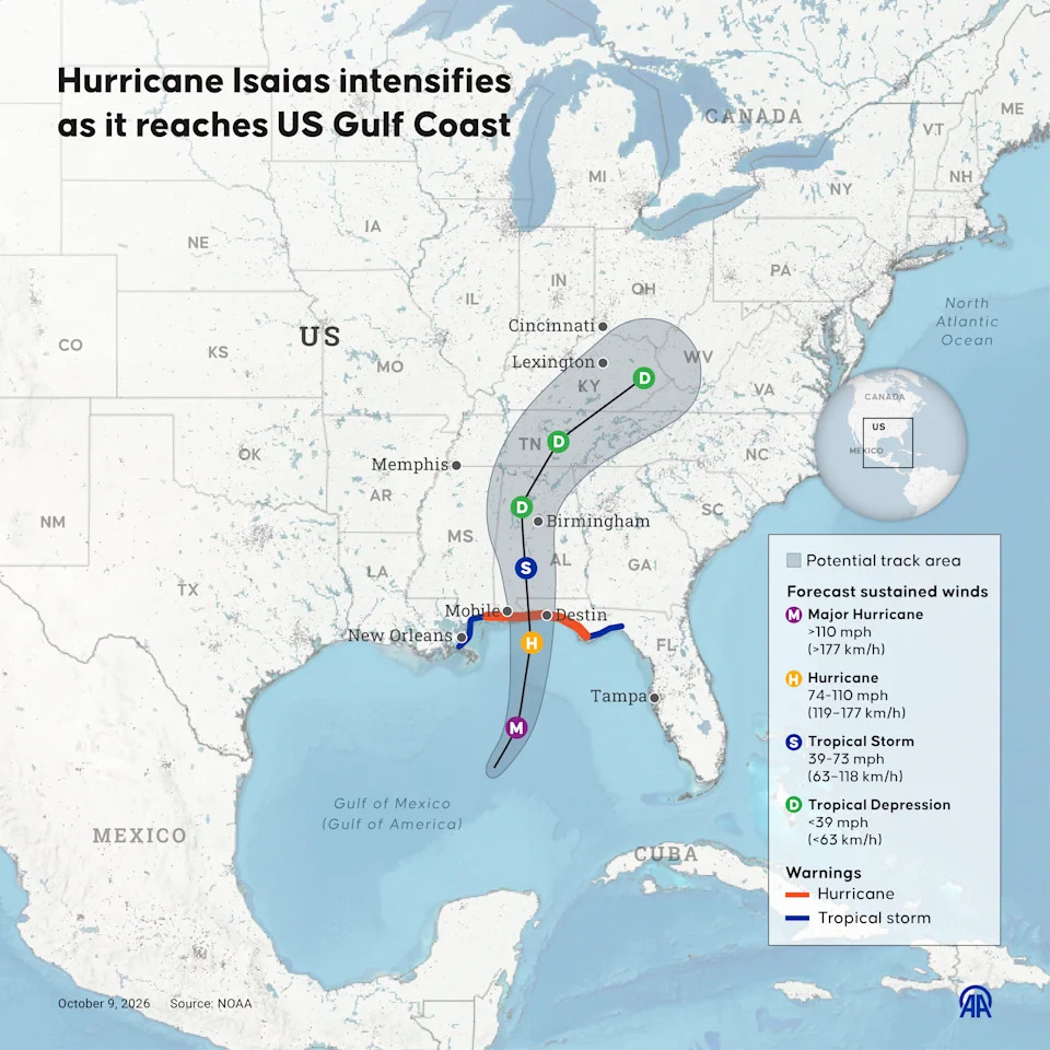
An infographic shows how Hurricane Isaias is set to intensify as it reaches the U.S. Gulf Coast.

This graphic based on NOAA data shows the potential track of Hurricane Isaias as it moves north from the Gulf of Mexico.

The image shows Isaias is forecast to strengthen into a major hurricane, with winds above 110 mph, before weakening slightly as it nears the Gulf Coast.

It is then forecast to weaken to a tropical storm over Alabama and to a tropical depression as it moves northeast through Tennessee and Kentucky toward West Virginia.

Hurricane Isaias could test FEMA's ability to respond to disasters following significant staffing reductions, according to the Guardian.

More than 4,300 FEMA employees left the agency in fiscal year 2025, representing about 17% of its workforce, according to a Government Accountability Office report. The departures included dozens of senior officials, raising concerns about the loss of experienced personnel.

Chris Currie, a director at the Government Accountability Office, told the Guardian, "It's not whether FEMA is going to respond. They're going to respond. It's more about the depth."

Disaster survivors advocate Ginny Goldman described the hurricane as FEMA's "biggest test" since the staffing reductions.

A FEMA spokesperson said, "Under President Trump and Secretary Mullin's leadership, the safety of the American people is DHS's top priority. FEMA incident management assistance teams are deploying to Alabama and Florida, and FEMA personnel are embedded in state emergency operations centers. FEMA is also prepositioning emergency supplies at Maxwell Air Force Base in Montgomery, Ala., to supplement state resources if requested."

Traffic came to a standstill on a highway leading out of Gulf Shores, Ala., Thursday, according to videos shared on social media, as residents and visitors prepared for the approaching storm.

Gov. Kay Ivey ordered non-residents to immediately evacuate Gulf Shores, Orange Beach and Dauphin Island.

"Traffic is bumper-to-bumper right now leaving Gulf Shores, Alabama," Jaden Pappenheim wrote on Facebook.

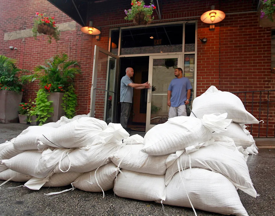
People speaking at a sandbagged entrance of the Manayunk Brewery and Restaurant in Philadelphia amid Hurricane Irene preparations.

Several Atlantic hurricane names beginning with the letter "I" have been fatal and caused catastrophic damage in recent years.

In 2011, Hurricane Irene sent cars bobbing down rivers, swept away covered bridges, put millions in the dark and killed dozens of people, including six in Vermont.

Category 4 Hurricane Ian in 2022 was the third-costliest storm to hit the U.S., causing $119.6 billion in total, as it wreaked widespread damage across Florida.

But why do hurricanes starting with this letter have such a terrible track record?

Hurricanes starting with "I" typically occur in the middle of June 1-Nov. 30 season, when warming ocean waters can supercharge a storm's energy.

"It's the 'I' storm, which usually we have a lot earlier in the year," Kristen Corbosiero, a professor of atmospheric and environmental sciences at the University at Albany, told the Associated Press. "It's always the 'I' storms that seem to cause problems."

Isaias is an exception because it has arrived later than usual, in part because the current super El Niño weather pattern has reduced the number of Atlantic hurricanes this season.

Pensacola International Airport in Florida announced it "will close to commercial operations" at 10 a.m. CT on Friday due to the hurricane.

It is unclear when the airport will reopen.

In a statement, the airport said, "Passengers with travel plans during the closure should contact their airlines directly to reschedule their itineraries and confirm the latest flight information.

"Thank you for your patience. Stay safe, Pensacola!"

One Minnesota couple was forced to abandon their planned beach wedding due to Isaias, according to the Pensacola News Journal.

Brooke and Devin Gertken had spent a year planning their wedding in Pensacola Beach, Florida, according to the website, but the approaching storm prevented their friend and officiant from flying in.

The couple instead headed to the Escambia County Courthouse, where they exchanged vows before government offices closed.

"Even though you plan and you did everything that you could, the weather is never probably going to listen to you," Brooke said. "But either way, it's always going to work out, and it's going to probably be better than you imagine it."

Oil and gas production has been impacted by the threat of Hurricane Isaias.

The U.S. Department of the Interior said the Marine Minerals Administration was "monitoring offshore operations and working with operators and state and federal partners."

Chevron and Shell were among the major oil companies to have begun shutting down some oil production sites.

The region accounts for almost 15% of crude pumped annually in the U.S.

About 63% of the oil production in the Gulf had been temporarily halted as of Thursday, according to the Associated Press. The Marine Minerals Administration said 121 of the Gulf's 371 manned oil platforms had been evacuated.

As NBC News reported, the timing of the hurricane compounds an existing issue, with the Iran war already disrupting energy supplies.

A new National Hurricane Center advisory says Hurricane Isaias has strengthened, with maximum sustained winds now at 110 mph, up from 105 mph.

The NHC says tropical storm conditions are expected within 24 hours somewhere in the tropical storm warning areas: the Jefferson-Plaquemines parish line in Louisiana to west of Ocean Springs, Miss., and east of the Bay-Gulf county line to the Aucilla River in Florida.

A tornado risk will begin late Friday afternoon, and continue tonight in the coastal areas of Alabama, the Florida Panhandle and far southwest Georgia, the advisory said. It will continue Saturday across parts of eastern Alabama, the Florida Panhandle, Georgia and the Carolinas.

Landfall is expected tonight or early Saturday, with Isaias likely to become a major hurricane this morning before weakening again as it approaches the coast.

David Schisle, Courtney Head, and Donald Knapp place plywood over the windows of Mr. Knapp's Islander Ice Cream restaurant in Gulf Breeze, Fla.

Residents boarded up windows as thousands of National Guard soldiers prepared to deploy ahead of Hurricane Isaias.

Coastal communities rushed to prepare as Alabama Gov. Kay Ivey ordered nonresidents to evacuate Gulf Shores, Orange Beach and Dauphin Island. According to the Associated Press, traffic backed up on a highway leading out of Gulf Shores, where beaches were closed to swimmers.

On Dauphin Island, officials also encouraged voluntary evacuations, particularly in low-lying areas vulnerable to storm surge. Mayor Jeff Collier said he did not anticipate substantial damage, "but at the same time, these things are very fickle and a little jog here or there, or some last-minute increase in strength — we just have to be prepared for the worst."

At least four Florida school districts canceled late-week classes, reports NBC Miami ahead of the hurricane.The governors of Florida and Alabama declared states of emergency for dozens of counties, with Florida's Ron DeSantis saying on Thursday about 5,000 National Guard troops were expected to mobilize by today."People should take it seriously," he said during a press conference at the state's Emergency Operations Center in Tallahassee. "Understand that you are going to have impacts. There's no question."

DeSantis earlier said he would be calling the hurricane "Isaiah," because the word "Isaias" was "weird."

The NHC says short, distinctive names are used to name storms because they make communication quicker and less error-prone. The U.S. started attributing female names to storms in 1953.

According to the latest National Hurricane Center advisory, the following watches and warnings are in place.

A storm surge warning is in effect for the mouth of the Mississippi River to the Suwannee River, Fla., while a storm surge watch is in effect for the Suwannee River to Yankeetown, Fla.

A hurricane warning is in effect for Ocean Springs, Miss., to the Bay-Gulf county line in Fla.

And a tropical storm warning is in effect for the Jefferson-Plaquemines parish line in Louisiana to west of Ocean Springs, Miss., and for east of the Bay-Gulf county line to the Aucilla River in Fla.

What does that mean?

A hurricane warning means hurricane conditions (sustained winds of 74 mph or higher) are expected somewhere within the warning area, per the NHC. It is typically issued 36 hours before the anticipated arrival of tropical-storm-force winds. "Preparations to protect life and property should be rushed to completion," the NHC said.

A tropical storm warning means tropical storm conditions (sustained winds of 39 to 73 mph) are expected somewhere within the warning area within 36 hours. A storm surge warning means there is a danger of "life-threatening inundation from rising water moving inland" — meaning flooding of normally dry land by seawater pushed ashore by the storm — during the next 36 hours.

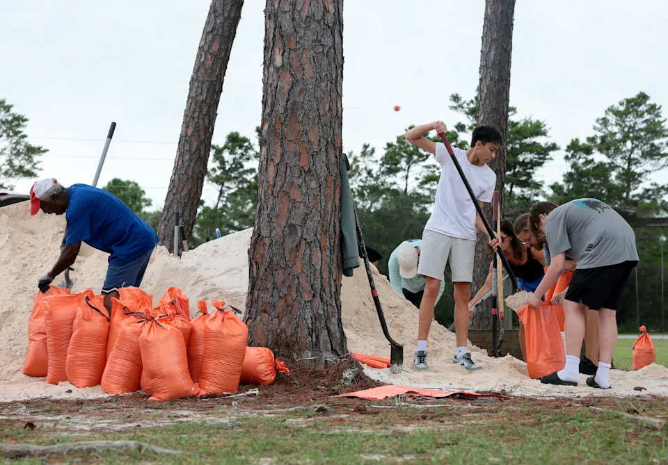
People fill sandbags that were provided by the city of Orange Beach.

Residents in Orange Beach, Al. could be seen stocking up on sandbags on Thursday ahead of Isaias's impact.

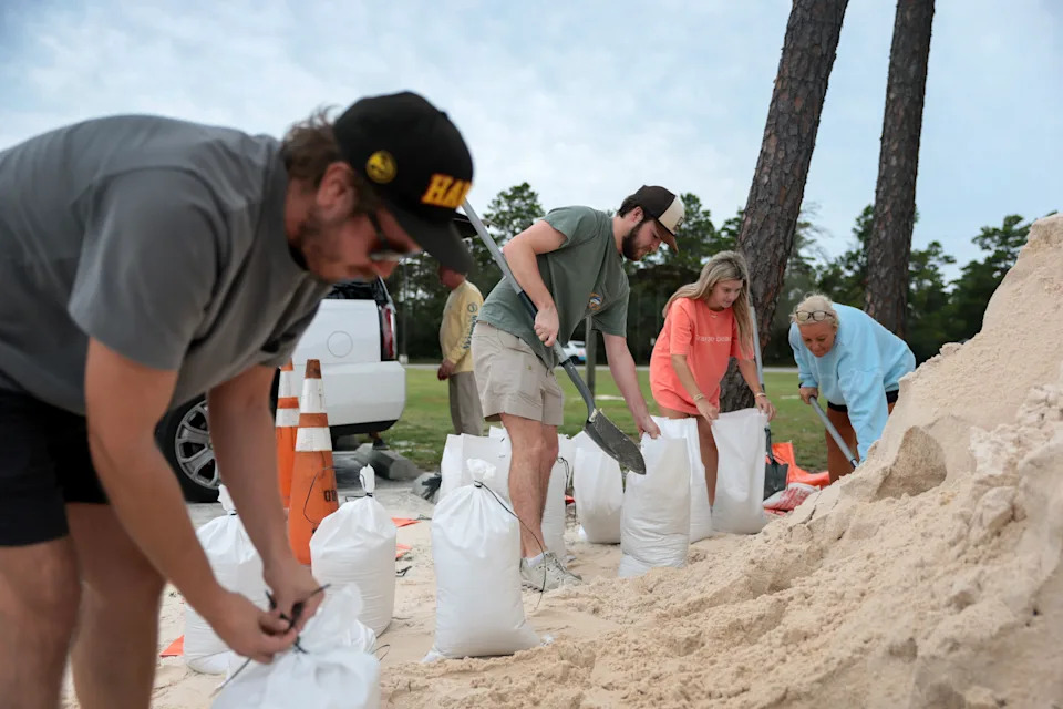
Sandbags can be an essential part of preparing for a hurricane for many.

According to the University of Florida, 10 sandbags might be sufficient to protect you if your home has suffered minor water intrusion from one or two doorways. However, if your home has experienced flooding from all sides, 10 sandbags will likely not be enough.

The bags should be paired with a heavy-duty plastic sheet and stacked properly — guidance can be found here. Residents should make sure the tarp is higher than the expected flood level and goes underneath the sandbags.

Brian Brunick (C) and other residents fill sandbags.

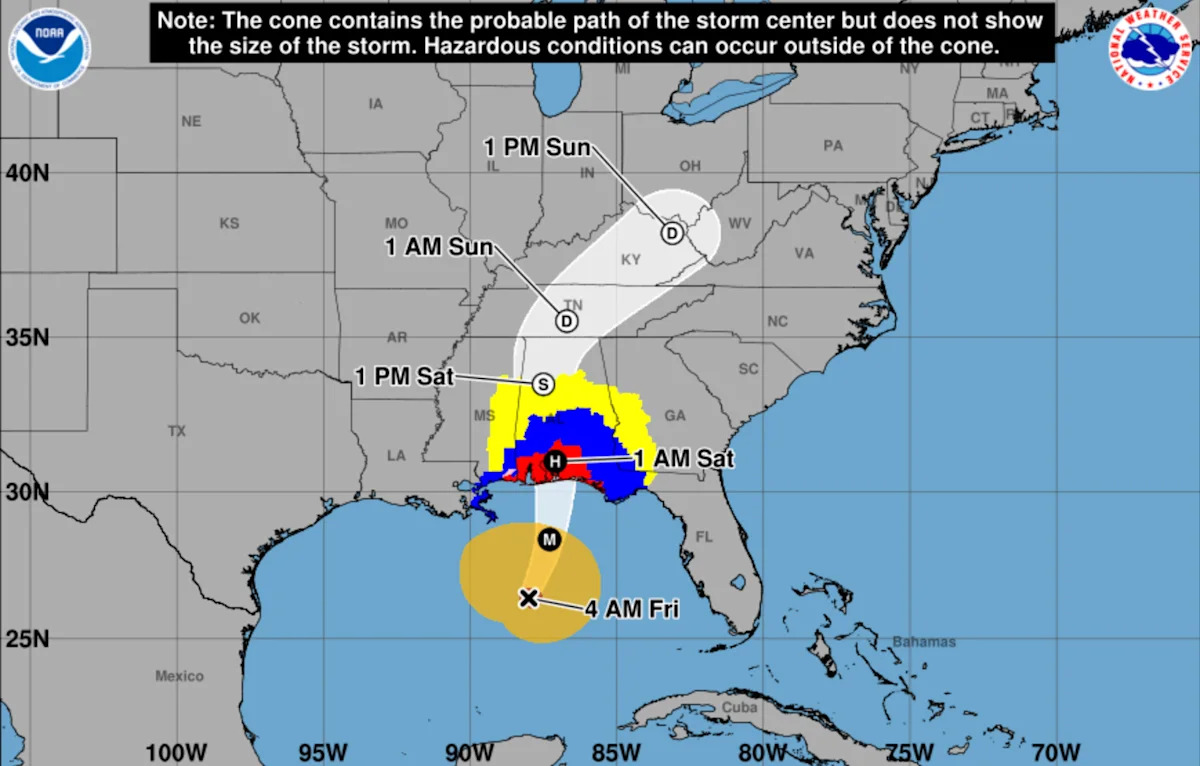
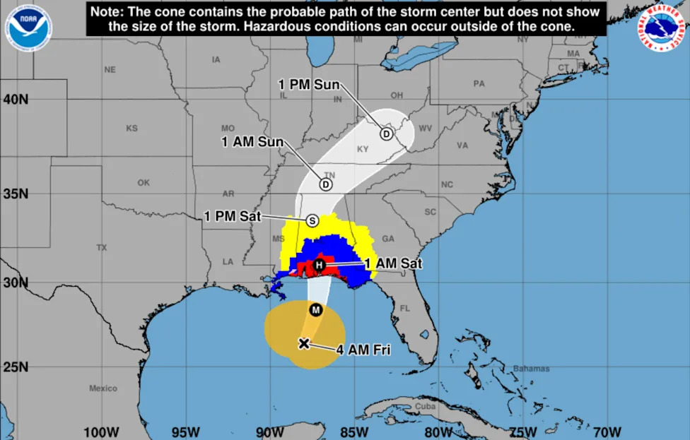
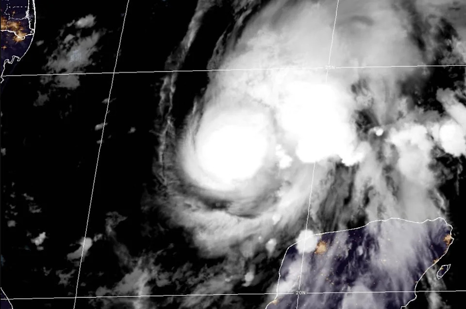
Hurricane Isaias is tracking across the Gulf.

A Category 2 hurricane has extremely dangerous winds between 96 and 110 mph that are projected to cause extensive damage, according to the Saffir-Simpson Hurricane Wind Scale.

While a Category 2 hurricane is dangerous, it is not considered to be a major hurricane on the scale.

Well-constructed frame homes could sustain major roof and siding damage. Many shallowly rooted trees will be snapped or uprooted, potentially blocking numerous roads. Near-total power loss is also expected, with outages potentially several days or even weeks.

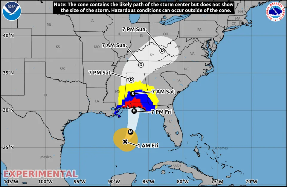
The projected path of the hurricane.

Hurricane Isaias is forecast to make landfall along the northern Gulf Coast tonight or early Saturday, with the NHC's tracker (above) indicating it could hit near the border of Alabama and the Florida Panhandle border.

The NHC says landfall could occur on the stretch between Ocean Springs, Miss., and the Bay/Gulf County line in Florida. The storm was in the central Gulf early Friday, about 230 miles south of the mouth of the Mississippi River, with maximum sustained winds of 105 mph. It is moving north-northeast at 14 mph and is expected to turn north later today.

After moving ashore, Isaias is forecast to weaken quickly, becoming a tropical storm over Alabama by early Saturday and a tropical depression by Saturday evening. By Sunday morning, it is expected to be over Tennessee, and by Sunday evening over Kentucky.
Comments
You must be logged in to comment.