yahoo Press
3 storms are churning in the Pacific as Nolo threatens Hawaii with 'catastrophic' flooding
Images
1 / 8
2 / 8

3 / 8

4 / 8

5 / 8
6 / 8

7 / 8

8 / 8
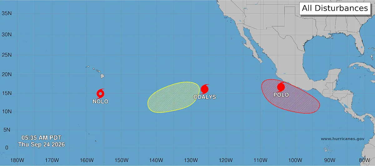
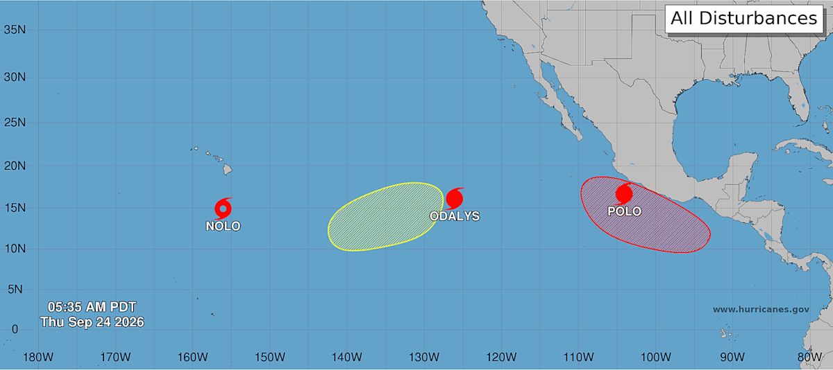
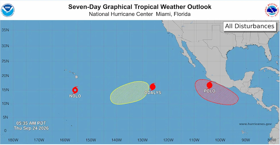
Hurricane season is showing no signs of slowing down, with three storms brewing in the Pacific.

Powerful Category 5 Hurricane Polo is sending bands of heavy rain and strong winds across Mexico's southwestern coast, while Tropical Storm Nolo is forecast to intensify into a hurricane late Thursday, threatening Hawaii's Big Island with potentially catastrophic flooding.

Some areas of Hawaii are expected to see up to 35 inches of rain, according to the National Hurricane Center.

A third storm, Hurricane Odalys, is churning over open water far from land.

Polo is forecast to remain a powerful major hurricane for the next few days, with its core expected to stay offshore before moving farther out to sea, according to the NHC. Nonetheless, the storm could produce up to eight inches of rain in parts of Guerrero, raising the risk of life-threatening flooding and mudslides.

Hurricane conditions caused by Tropical Storm Nolo are possible as early as Friday night in Hawaii County, the NHC said. The National Weather Service said Tropical Storm Nolo would likely strengthen before closing in on the Big Island on Friday or Saturday.

John Bravender, a weather service warning coordination meteorologist, said during a news conference Wednesday afternoon that the heavy downpour "could cause catastrophic flooding," adding, "but when you put that on top of grounds that we've been raining off and on for the last couple of months … that rain could cause even more damage."

Hawaii County Mayor Kimo Alameda told residents, "This is a very serious situation. We do believe that the rain is going to come. It's coming already."

Activity in the Pacific Ocean is being fueled by a "supersized" El Niño climate pattern.

El Niño affects hurricane severity in both the Atlantic and the Pacific. This year's particularly powerful  El Niño conditions, which could become the strongest on record, have led to fewer hurricanes in the Atlantic (particularly the Caribbean) and more in the Pacific due to increased rising air over the tropical Pacific and sinking air over the tropical Atlantic.

Weather changes fast. Get real-time alerts for your area on the new Yahoo Weather app.

Here's the location, path and status of each of the storms:

According to the National Hurricane Center, Hurricane Polo is a Category 5 storm and is expected to remain a powerful major hurricane for the next few days.

As of 8 a.m. ET Thursday:

Polo was located about 160 miles south of Manzanillo, Mexico, and about 175 miles west-southwest of Zihuatanejo, Mexico.

It had maximum sustained winds of 160 mph.

It was moving northwest at 9 mph.

A tropical storm warning is in effect from Tecpan de Galeana to Manzanillo, and a tropical storm watch extends west of Manzanillo to Playa Perula.

Coastal parts of Guerrero could see 4 to 6 inches of rain, with isolated totals up to 8 inches, through Thursday.

Coastal parts of Michoacan, Colima and Jalisco could get 2 to 4 inches. The rainfall could produce life-threatening flooding and mudslides, especially in areas of steep terrain.

Swells from Polo will affect southwestern Mexico over the next couple of days and spread toward west-central Mexico and Baja California Sur on Friday and into the weekend, bringing life-threatening surf, rip currents and coastal flooding.

The National Hurricane Center said Tropical Storm Nolo was forecast to strengthen into a hurricane late Thursday and could become a major hurricane by the weekend.

A hurricane watch is in effect for Hawaii County, where hurricane conditions are possible by Friday night.

 Nolo is expected to move north or north-northeast through Friday before making a sharp turn west near the Big Island by Saturday.

As of 8 a.m. ET Thursday:

Nolo was located about 285 miles south of South Point, Hawaii, and about 460 miles south-southeast of Honolulu.

It had maximum sustained winds of 50 mph.

It was stationary.

The Big Island could see 15 to 20 inches of rain, with a handful of places seeing up to 35 inches. The conditions may produce catastrophic, life-threatening flooding and mudslides, especially in steep terrain.

Maui could get 5 to 10 inches of rainfall, with up to 20 inches in some areas, and the rest of the Hawaiian Islands could see 1 to 3 inches of rain, with up to 6 inches possible.

Storm surge could raise water levels 1 to 3 feet above ground in parts of Hawaii County.

Swells from Nolo are expected to reach the Big Island's east- and south-facing shores by Friday, building through the weekend and bringing life-threatening surf and rip-current conditions.

The National Hurricane Center said Hurricane Odalys posed no threat to land. There are no coastal watches or warnings in effect.

Odalys is expected to strengthen further over the next day or so before weakening later this week.

 As of 5 a.m. ET Thursday:

Odalys was located about 1,145 miles west-southwest of the southern tip of Baja California.

It had maximum sustained winds of 85 mph.

It was moving east-northeast at 8 mph.
Comments
You must be logged in to comment.