yahoo Press
Here comes 'Atlantic Niña': What does it mean for the hurricane season?
Images
1 / 5

2 / 5

3 / 5

4 / 5

5 / 5
Think La Niña is just a Pacific thing? Think again.

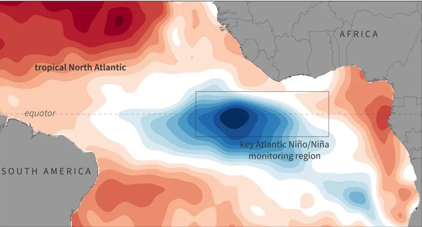
No, now it's time for La Niña's cousin, the "Atlantic Niña" climate pattern, which appears to have been forming over the past few weeks, to take a bow.

According to a report on the Severe Weather Europe website, "a rare 'Atlantic Niña' has appeared in the tropics, just as a powerful Super El Niño continues to build in the Pacific. These two ocean anomalies may look opposite on the map, but their atmospheric impact is pushing in the same direction, creating an atmospheric shield for the United States hurricane season."

More: Could we stop El Niño by brightening clouds? New study explores how

Atlantic Niña is a relatively rare cooling of sea-surface temperatures in the equatorial Atlantic Ocean that can alter rainfall and wind patterns across the tropics and, at times, influence Atlantic hurricane activity, though its effects are generally weaker and more localized than those of Pacific La Niña, according to Climate.gov.

Specifically, Atlantic Niña is the cold phase of a natural climate pattern known as the Atlantic zonal mode. (Zonal means "along lines of latitude.") This pattern, just like ENSO (El Niño-Southern Oscillation), swings between cold and warm phases every few years.

Typically, sea-surface temperatures in the eastern equatorial Atlantic have a somewhat surprising seasonal cycle. The warmest waters of the year occur in spring, while the coolest waters of the year — below 77 degrees Fahrenheit — occur from July to August.

Atlantic Niña events are not unprecedented, but strong summer events are relatively rare, according to the report in Severe Weather Europe. "If the current cooling persists and the seasonal anomaly ends below −0.8 degrees F, the 2026 event would become only the sixth such Atlantic Niña in over 40 years of historical data."

Atlantic Niña appears to slightly suppress Atlantic hurricane activity, though its influence is much weaker than El Niño's or La Niña's, according to an article in the Conversation. "Cooling waters along the equatorial Atlantic reduce the heat and moisture available for tropical thunderstorms, making it somewhat harder for disturbances to organize and intensify."

In 2026, the emerging Atlantic Niña combined with a strong El Niño could work in the same direction, both acting to diminish Atlantic hurricane activity, according to NOAA.

Doyle Rice is a national correspondent for USA TODAY, with a focus on weather and climate.

This article originally appeared on USA TODAY: Here comes 'Atlantic Niña': What does it mean for the hurricane season?
Comments
You must be logged in to comment.