yahoo Press
The chances of El Niño hitting the planet stand at 80%. Here's how it could wreak havoc on the weather.
Images
1 / 8
2 / 8

3 / 8

4 / 8

5 / 8

6 / 8

7 / 8

8 / 8
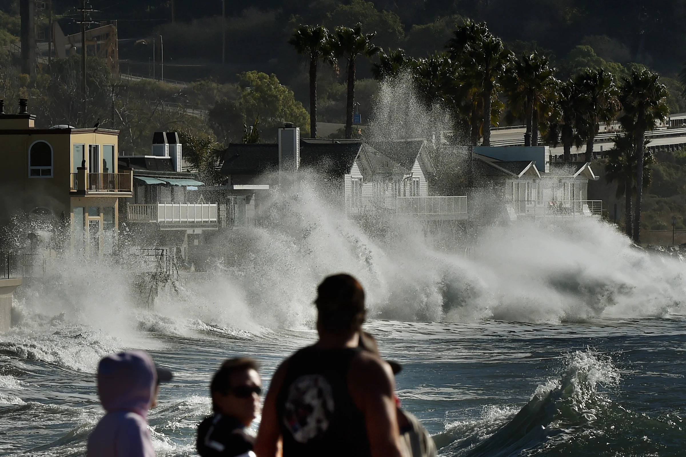
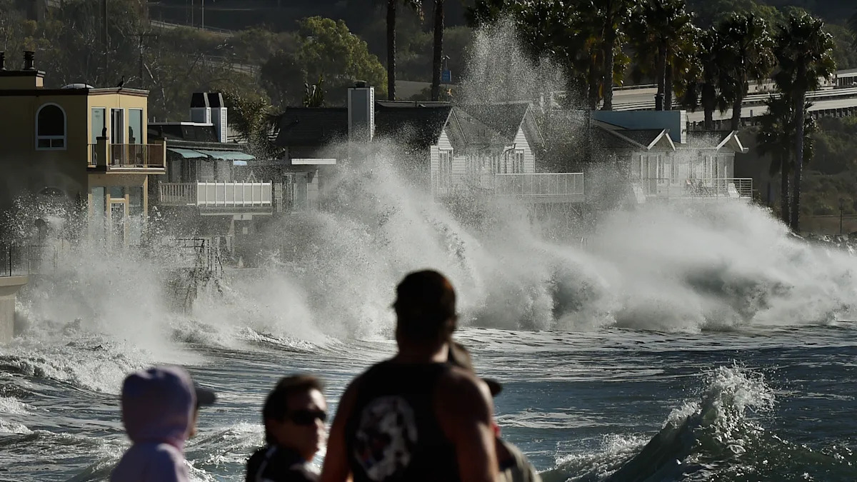
An El Niño event that could drive up global temperatures and increase the risk of extreme weather is expected to hit in the coming months, the United Nations weather agency warned on Tuesday. According to the World Meteorological Organization (WMO), El Niño — a periodic warming of sea surface temperatures in the central and eastern Pacific Ocean — has an 80% chance of forming before September and a 90% chance of persisting until November. The weather agency said warm ocean waters were driving the development of El Niño. “We need to prepare for a potentially strong El Niño event, which will exacerbate drought and heavy rainfall and increase the risk of heat waves both on land and in the ocean,” said WMO Secretary-General Celeste Saulo. “Extreme heat alone is already one of the deadliest climate hazards we face, and an El Niño event could intensify the threat,” she added. “Communities that were already struggling will be pushed farther beyond their limits.” “The world must treat it as the urgent climate warning it is. El Niño conditions will pour fuel on the fire of a warming world,” said U.N. Secretary-General António Guterres, who urged a shift away from fossil fuels toward renewable energy. What’s less certain is how strong this year’s El Niño will be. According to the latest National Weather Service (NWS) forecast, issued in May, the odds of a “super El Niño” occurring between November 2026 and January 2027 have risen from 25% to 37% — meaning that the U.S. and the world as a whole might be in for some wild weather later this year. Such an event could saddle the southern half of the United States with a much cooler and wetter winter and ultimately fuel what could turn out to be the hottest year on record. Here’s what El Niño is — and how its rare “super” variant could wreak havoc come winter. Normally, Pacific trade winds blow west across the equator, carrying warm South American water toward Asia. Cold water then “upwells” from the depths to replace the warmer surface water that’s been pushed away. El Niño is a natural climate cycle that disrupts this pattern. It’s triggered by weaker-than-usual trade winds — winds that end up allowing much of that warm water to flow back toward the west coast of the Americas. Ultimately, that warmer water forces the Pacific jet stream — a high-altitude air current that acts as a 7,000-mile “conveyor belt” pushing storms east across the Pacific toward North America — to move south of its usual path, altering weather patterns across the U.S. and the globe. La Niña is the exact opposite: stronger trade winds, colder water and a Pacific jet stream that moves north rather than south. El Niño and La Niña happen roughly every two to seven years and last nine to 12 months. El Niño generally arises more frequently than La Niña. Meteorologists measure the strength of El Niño by how much the water temperature rises above average in a patch of the equatorial Pacific. The threshold for a weak El Niño is 0.5 degrees Celsius (0.9 degrees Fahrenheit). Right now, the temperature is just below that mark, but NWS expects it to warm into weak El Niño territory sometime this month. But to become a super, or “very strong,” El Niño, the equatorial Pacific would ultimately need to heat up by 2 degrees Celsius. That’s a lot less common. Still, scientists can see it happening if the trade winds continue to weaken in sync with rising ocean temperatures. Already, some “typically reliable computer models show this year’s potential “super El Niño” could even be the strongest on record,” CNN reports. If a “super El Niño” develops in 2026, it would be the first since 2015-2016 — one of the strongest on record, according to the National Oceanic and Atmospheric Administration (NOAA). Others occurred in 1997-1998, 1982-1983 and 1972-1973. And while some national weather agencies have forecast the strongest El Niño in a decade, the WMO is more circumspect. Nonetheless, Guterres said it was a reminder of the need for a shift away from fossil fuels. “The science is clear: El Niño is arriving on our doorstep in the coming months with 90% certainty. Impacts will hit even harder, travel even farther, and cross borders with devastating speed,” he said. It’s hard to say exactly. The 2015-2016 “super El Niño,” for example, didn’t deliver a wetter-than-average winter in Southern California — one of its typical trademarks. At the same time, climate change has made what we know about previous El Niños less helpful for informing what could come next, because the ocean is already significantly warmer today than it was back then. But some effects are relatively predictable. In early May, NOAA said it’s “very likely” 2026 will be one of the five hottest years on record. That’s without accounting for El Niño’s warming impact. A “super El Niño” could make 2026 or 2027 the hottest year on record, displacing 2024. Stronger El Niños also tend to flip the usual hurricane season equation, suppressing storms in the Caribbean and tropical Atlantic while amplifying them in the central and eastern Pacific. More tropical threats to Hawaii and the Southwest U.S. are a possibility. Related: NOAA's 2026 Atlantic hurricane season forecast: What you need to know Extremes of wetness and dryness — and heat and cold — are possible as well. Winter tends to get warmer in the northern half of North America and cooler and wetter in the southern half, especially in the Southeast and along the Gulf Coast. Elsewhere, drought could afflict the Caribbean, while India and Southeast Asia might see fewer summer monsoons. The economic impact of these changes could be massive. According to a 2023 study published in the journal Science, the 1982-83 El Niño led to $4.1 trillion in global income losses, and its 1997-98 successor cut global income by $5.7 trillion. Either way, “stronger El Niño events do not ensure strong impacts; they can only make certain impacts more likely,” Michelle L’Heureux, a physical scientist at NOAA, told USA Today. “There is still enough uncertainty that seeing a weaker outcome would not be a surprise.”
Comments
You must be logged in to comment.