bbc Press
UK weather: Warm weekend forecast before temperatures drop next week
Images

1 / 20

2 / 20
3 / 20
4 / 20

5 / 20

6 / 20
7 / 20

8 / 20

9 / 20

10 / 20

11 / 20
12 / 20

13 / 20

14 / 20

15 / 20

16 / 20

17 / 20

18 / 20

19 / 20

20 / 20
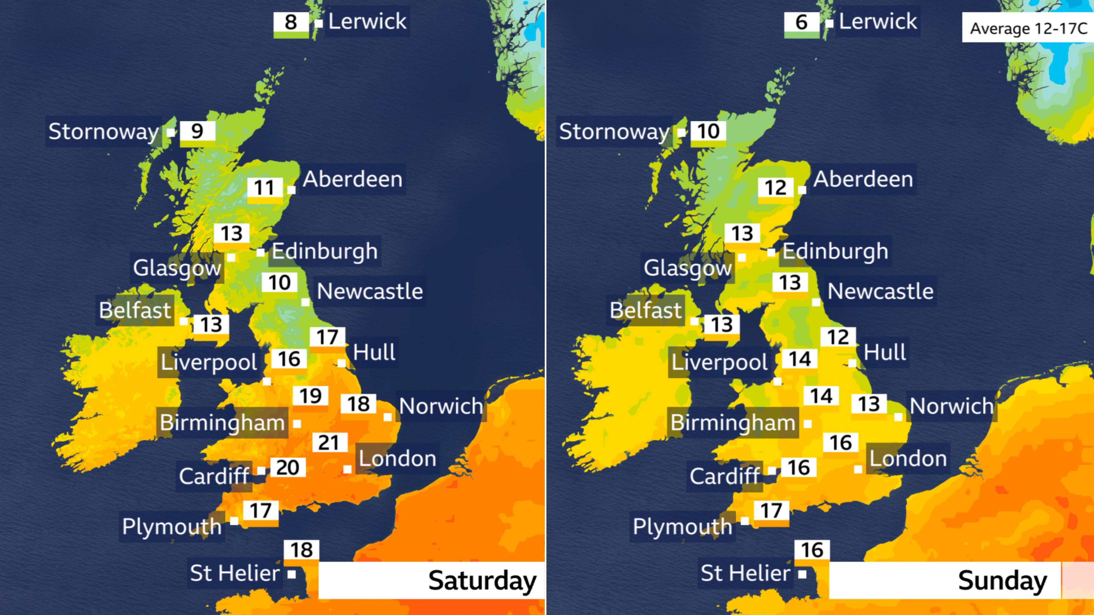
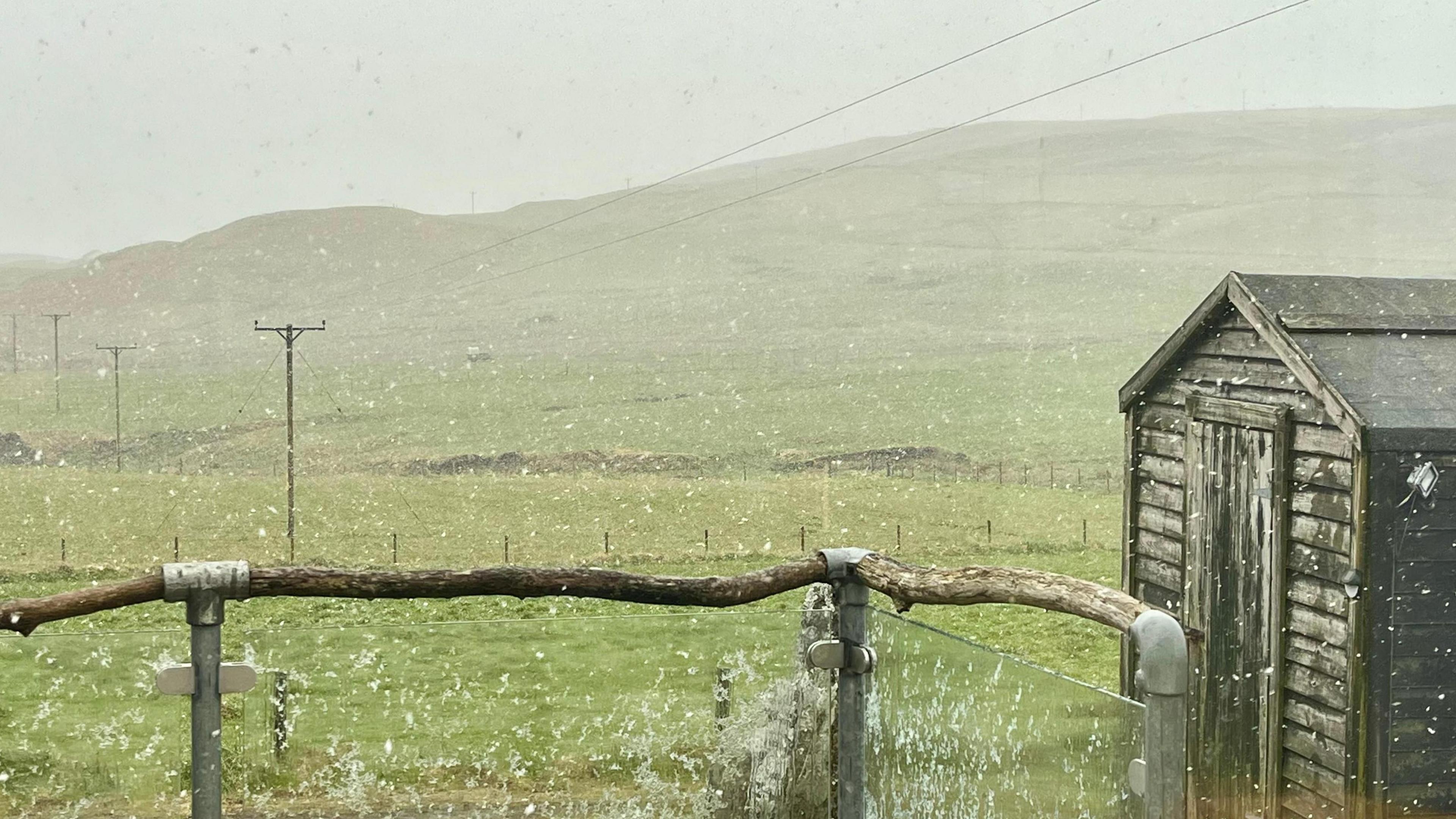
Periods of dry and sunny weather are on the cards for most of the UK this weekend before chilly Arctic air sends temperatures falling into the single digits next week.

If you've got outdoor plans this weekend the good news is that most will experience dry and sunny weather at times, despite the chance of rain for some.

Warmer conditions are also expected across southern areas for a time, before temperatures drop through the weekend.

Next week could bring even chillier weather as winds from a general northerly direction start to dominate.

Some of the warmest weather of this coming week is forecast on Saturday, although this will be confined to southern and central parts of England.

With light south-westerly winds and some reasonable spells of sunshine, temperatures in southern counties and the Midlands could reach highs of between 19 and 21 Celsius (66-71F). The May average temperature in these areas is 16 or 17 Celsius (61-63F).

Temperatures will be much closer to the seasonal average elsewhere across the country, though it may feel rather cool in the cloudier moments.

Cloudiest will be parts of south-east Scotland and northern England, where a weather front will bring a spell of rain for many through the day.

Showers are also possible for a few in northern Scotland as well as Wales and south-west England.

The weekend begins warm across southern areas before cooler air in the north spreads to all areas.

Gardeners and growers across the northern half of the UK will then need to be on alert on Saturday night as a frost is possible.

Temperatures will also have dropped across southern parts on Sunday as a cold weather front bringing patchy overnight drizzle clears south.

However, it does mean that many of us will have a dry day on Sunday, and certainly a much brighter one compared to Saturday for northern England and south-east Scotland.

Showery rain will be limited to northern Scotland and perhaps the Channel Islands.

Blustery winds through the English Channel and across southern England and Wales will add to the cooler feel, but despite temperatures dropping a little elsewhere too the strength of the May sun should still make it feel pleasant.

What you need to know about hayfever season

If you've seen forecasts of snow next week flash up on your social media feed over the last few days, you may be thinking that winter is about to return.

While snow is not expected over the vast majority of the UK, it is true that rather cool conditions for May are set to dominate.

With high pressure centred to the west of the UK, winds will mainly come from that chillier northerly direction. During the second half of the week our air will have originated from around the Arctic Circle in northern Scandinavia.

Daytime temperatures for most will be much colder than normal at 9-14 Celsius (48-57F) in many areas.

Areas of low pressure crossing southwards across the country will bring a greater likelihood of rain and, like last week, some snow in Shetland and the Scottish mountains cannot be ruled out.

As well as snow, last week also brought the UK its coldest May conditions for nearly 30 years. Tomintoul in Moray, Scotland recorded a low of -6.8C (20F) on the night of the 5/6 May. This was the lowest temperature recorded in May since 1997 when the same temperature was reported at Leadhills, Lanarkshire.

Further night frosts are expected in places during the week ahead.

Snow briefly fell in the showers across Shetland on Wednesday

Spring is a transition season, notorious for big ups and downs in temperature.

Wind direction is often key. Winds from a general northerly tap into air that is still fairly cold in and around the Arctic. At the same time, the higher and stronger sun is warming up continental Europe and winds from the south can easily bring surges of heat. Even without the wind, that stronger sunshine can temper any chill during daylight hours.

The UK's highest May temperature was 32.8C (91F), recorded at locations in London and south-east England on 29 May 1944.

Last year brought the warmest ever start to May with a high of 29.3C (84.7F) at Kew Gardens, London on 1 May 2025.

However cold weather can also leave its mark.

In May 1941 overnight temperatures at Lynford, Norfolk fell to -9.4C (15.1F) on both the fourth and 11th of the month.

Significant snow can also occur.

Birmingham had its worst May snowstorm for 60 years in 1955, and wintry weather returned to the city on 2 May 1979 with snow blanketing many areas for the bank holiday.

Spring is 'fastest-warming' season in the UK

Monthly Outlook

Is the UK heading for another drought this summer?
Comments
You must be logged in to comment.