yahoo Press
Cheboygan Dam teeters near spillover as tensions escalate Up North
Images
1 / 15
2 / 15

3 / 15

4 / 15

5 / 15

6 / 15
7 / 15

8 / 15
9 / 15

10 / 15
11 / 15

12 / 15

13 / 15

14 / 15

15 / 15
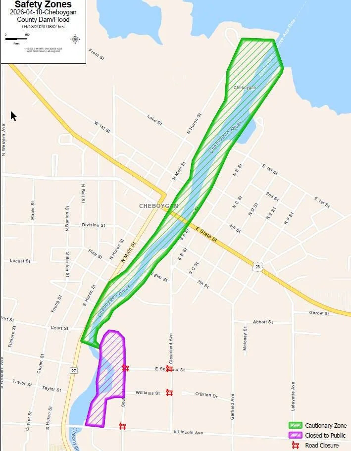
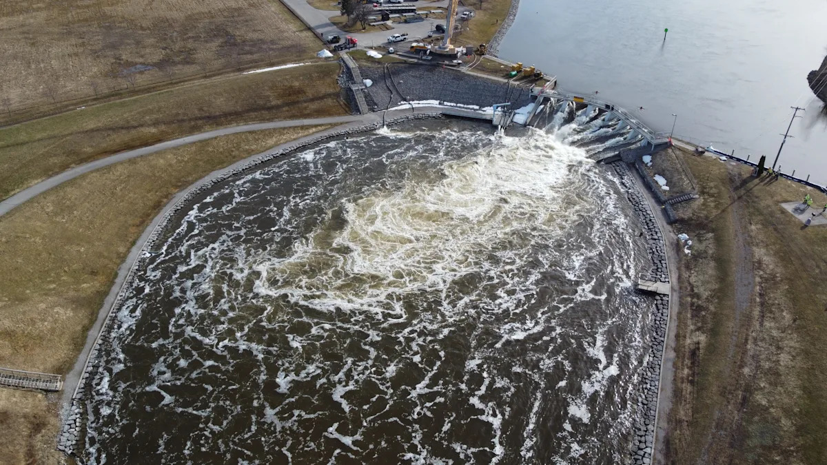
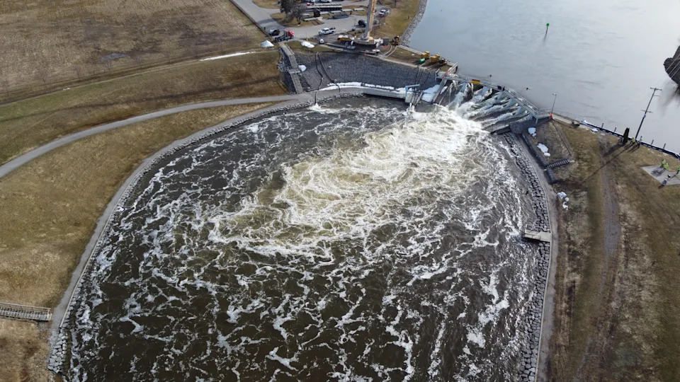
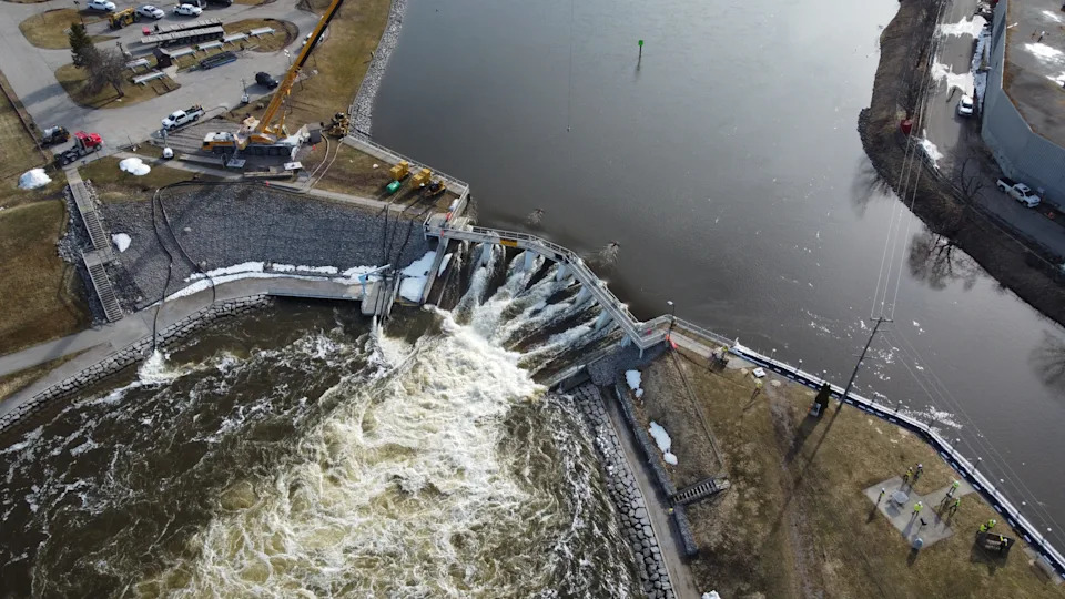
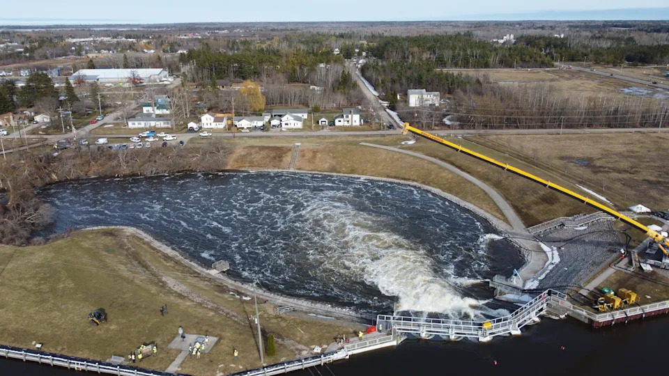
Cheboygan residents near the community's dam on the Cheboygan River remained on stand-by to evacuate Monday, as water levels remained precariously close to spilling over the dam and potentially causing a dam failure − as ominous weather news provided no relief.

According to a Monday, April 13 Facebook post by the Cheboygan County Sheriff's Office, water levels reached the "ready" mark, of emergency managers' "ready, set, go" warning system. The "ready" designation means residents should:

Prepare a go-bag (medications, important documents, etc.) and review your family plan.

Secure outdoor items and move valuables to higher levels.

Avoid riverbanks and low-lying areas.

Monitor official updates and be ready to act.

The “ready, set, go” safety approach includes these steps:

Ready: When water is 12 inches below the top of the dam with levels rising 3 inches a day or more. Plan and/or pack in the event an evacuation becomes necessary.

Set: When water reaches 6 inches below the top of the dam, with water levels rising at a rate of 3 inches per day or levels rising 3 inches per day and predicted to top the dam within 48 hours. Prepare by packing and preparing your family, pets and vehicle for potential departure.

Go: When water levels are 1 inch below the top of the dam with a high probability of topping it, with the potential for failure occurring. Follow evacuation orders; roadblocks may be installed around the perimeters.

Officials say if an evacuation is ordered, residents will receive an IPAWS (Integrated Public Alert and Warning System) emergency alert on their phone.

Latest updates: Cheboygan Dam and water levels as residents prepare to evacuate

The sheriff's office later Monday afternoon posted to Facebook a map showing a "cautionary zone" of potential flooding downriver from the dam that shows potential flooding areas along both riverbanks extending into North Main Street and North Huron Street on the river's northwest bank, and into South A Street on its southeastern bank. The Cheboygan River flows northeast through the city before ending at northern Lake Huron.

"Water levels remain unpredictable," sheriff's officials stated, adding that the cautionary zone shown along the river "is the target area for potential flooding.

"Please avoid this area if possible. Community members within this area should be prepared with a go bag and secure valuables. The Cautionary Zone will be updated as the situation evolves."

Residents outside the cautionary zone should still maintain high awareness and monitor the Cheboygan County Sheriff’s Office Facebook page for updates, sheriff's officials said.

The Michigan State Police Emergency Management & Homeland Security Division also established a webpage at which to receive the latest information, michigan.gov/cheboygandam.

Cheboygan County Sheriff Todd Ross encouraged residents to get their information on the evolving dam situation from official channels.

"There's a lot of misinformation going around right now about people that could be affected by this that aren't going to be," he said.

Gov. Gretchen Whitmer activated the state's Emergency Operations Center on Friday, April 10.

The Michigan Department of Transportation also raised the U.S. 23 bascule bridge in Cheboygan on Monday, April 13 and closed it to roadway traffic as a preventative measure while officials continue monitoring water levels at the Cheboygan Lock and Dam Complex.

According to MDOT, the bridge closure is intended to protect against potential damage from debris flowing down the Cheboygan River and to keep vehicle occupants and pedestrians safe. During the bridge closure, traffic will be detoured south to the Lincoln Avenue Bridge.

MDOT officials said there is no timeline for reopening the bridge, which will need to be inspected before it can be re-opened. An operator from the Cheboygan County Road Commission will be on site and will be ready to open the bridge in an emergency if needed.

A large mechanical crane was used overnight into Monday morning to remove gates on the dam to allow more water to flow through, and agencies including the DNR, Federal Energy Regulatory Commission and Consumers Energy were working Monday to activate deactivated hydroelectric turbines on the dam, allowing further water flow-through.

According to Michigan State Police, water levels stood at 13.75 inches from the top of the dam as of Monday afternoon, having risen 2.25 inches from the day before. Water levels spilling over a dam, known as overtopping, are considered dangerous due to the potential for structural damage and failure.

Jim Keysor, a meteorologist with the National Weather Service in Gaylord, said the Cheboygan Dam is facing an onslaught of spring water far beyond the usual.

"We had a lot of late season snowfall in that area, particularly in in March, where some of that area as you head towards Cheboygan received up to two feet of snow with a lot of water in that snow, on the order of three or four inches," he said.

"You had a combination of a lot of water sitting in a snowpack that was late-season, and now in the last few weeks we've also had well above normal rainfall across that area as well. Everything came together to result in too much water all at one time."

The short-term forecast doesn't look good for relief.

"We have several systems that are going to bring rain to the area over the next several days, and so some of these areas that are already waterlogged may receive at least another two or three inches of rain over this next week," Keysor said. "And of course, there's just no place for it to go right now."

Some of the ground in the area also remains frozen, he said, which means that instead of being absorbed, rainfall is running off more quickly into tributaries and eventually the Cheboygan River.

The Cheboygan Lock and Dam, originally completed in 1869, is over 150 years old. The current dam structure, used for hydroelectric power, was completed in 1922. It is a 21-foot high, 580-foot long dam that raises or lowers recreational boats by approximately 15–16 feet, connecting Lake Huron with the Inland Waterway, a 38-mile-long series of rivers and lakes in Emmet and Cheboygan counties that includes Crooked Lake, Crooked River, Burt Lake, Indian River, Mullett Lake and the Cheboygan River.

More: State activates emergency center amid risk Cheboygan Dam could overtop

A dam breach would not only cause immediate flooding impacts downstream in the Cheboygan area, but water level and other impacts throughout the connected waterways. Heather Huffstutler, executive director of the nonprofit Tip of the Mitt Watershed Council, said she and her staff don't have the engineering or hydrology data to estimate potential impacts.

"The Cheboygan River watershed is an important watershed in northern Michigan, for biodiversity, recreation and local economies," she said. "The watershed is the largest in the Tip of the Mitt region, encompassing over 900,000 acres." That's about the same size as Wayne and Oakland counties combined.

"This means that over six river systems and more than six inland lakes all drain into the Cheboygan River system, culminating at the Cheboygan Lock and Dam facility," Huffstutler said.

Kathy Eustice lives on the Cheboygan River about two miles upstream from the dam.

"We are used to all the water that comes this way in the spring," she said. "But we’ve never run into something like this. It’s uncharted territory."

Eustice attended her yoga class on Monday as usual − "life goes on," she said. But she also began taking precautions, throwing items into her car, filling up her gas tank on the way home, parking the car outside the garage in case the power went out.

"I have anxiety; it’s something that’s out of my control," she said. "There’s a lot of anxiety out there, and people with misinformation, I think."

Further upriver, Indian River Marina co-owner Michael Ryan is sandbagging around his riverfront snack shop, where water has risen to flood the floor.

"I’ve owned the marina for about 13 years, and even speaking with the locals who have been here much longer than I have, we’ve never seen it at levels this high before," he said.

"Most of our docks are either underwater or within 6 to 12 inches of being under water."

Ryan said he is pumping water away from the shop and off his property − but that's putting it back into the river. "It's a losing battle," he said.

More: Latest on Cheboygan Dam, water levels as residents prepare to evacuate

The Cheboygan Lock and Dam Complex is comprised of the Cheboygan Lock and Dam, as well as a privately owned hydroelectric facility, the DNR noted. The complex is regulated by the Federal Energy Regulatory Commission.

Here are some key details on the Cheboygan Dam, according to Dams of the World:

Watershed: about 1,455 square miles.

River: Cheboygan River

Primary Purpose: Hydroelectric

Type: Timber crib earth

Commissioned: 1922

Dam Height: 21 feet

Dam Length: 580 feet

Dam Capacity: 83,000 acre feet

Oversight: regulated by the Federal Energy Regulatory Commission.

Jalen Williams, Jared Greenleaf, Jillian Fellows and Sarah Moore contributed to this report. Contact Keith Matheny: kmatheny@freepress.com.

This article originally appeared on Detroit Free Press: Cheboygan Dam teeters near spillover as tensions escalate
Comments
You must be logged in to comment.